Key Features
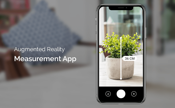
Real-Time AR Visualization: The AR Measuring Tape will leverage the power of Unity AR Foundation to provide a seamless AR experience. Users will be able to view the physical world through their device's camera while virtual measuring lines and points are superimposed onto objects in real-time.
Distance Measurement: The primary functionality of the app will be to measure distances between two points in the real world. By tapping on the screen, users can place anchor points on objects they wish to measure, and the app will display the distance between these points.
Basic Ray Tracing: To ensure accurate measurements, the app will utilize basic ray tracing techniques. When a user places an anchor point on an object, a virtual ray will be cast from the camera's position towards the object, and the app will calculate the distance based on the intersection point of the ray and the object's surface.
Unit Conversion: The app will support various units of measurement, such as centimeters, inches, feet, and meters. Users can easily switch between units according to their preferences or project requirements.
Visual Feedback and Guidance: The application will provide visual feedback to assist users in accurately placing anchor points. For instance, the app might display a subtle grid or color-coded indicators to highlight the points of interest on the object.
Save and Share Measurements: Users will have the option to save their measurements for future reference or share them with others. This feature will enhance the utility of the app for both personal and professional use.
User-Friendly Interface: The app will have an intuitive and user-friendly interface, making it accessible to a wide range of users, including DIY enthusiasts, architects, engineers, and students.
Conclusion
The AR Measuring Tape project combines the power of Unity AR Foundation and basic ray tracing techniques to create an efficient and accurate tool for measuring distances in the real world. Whether for home improvement projects, interior design, or construction tasks, this application will empower users with the ability to make precise measurements using their mobile devices, making it an invaluable tool in various fields.